What’s Under DFW? A Look at North Texas’ Geology and Fault Lines
North Texas sits atop an intricate network of 250+ mapped fault segments with a cumulative length of roughly 1,800 miles beneath the Dallas–Fort Worth metroplex. You'll find several geologic time periods represented in the region's rock formations, which dip gently eastward toward the Gulf.
Since 2008, previously quiet faults have produced hundreds of small earthquakes, and many clusters correlate with wastewater-injection–related pressure changes from oil and gas operations. Understanding this hidden underground landscape explains why the ground occasionally shakes.
Mapping the Unseen: North Texas' Complex Fault Network
https://www.youtube.com/watch?v=qW4m_QoG2Pw
What lies beneath the surface of North Texas? An extensive network of mapped faults concentrated in the Fort Worth Basin, forming an underground web most residents never see. Current compilations identify about 251 faults, with more likely to be refined as new data emerge. While historically quiet, many are stress-sensitive, meaning subsurface pore-pressure changes can promote slip.
Research shows that key drivers include deep wastewater injection, which raises formation pressures and can reactivate faults that were otherwise stable. The distribution isn't uniform—some corridors show dense fault clustering, implying interconnected systems rather than isolated fractures.
This hidden geology continues to be clarified through local seismic arrays, 3-D subsurface mapping, and reanalysis of industry well and seismic data.
Between Two Giants: The Geological Setting of Dallas–Fort Worth
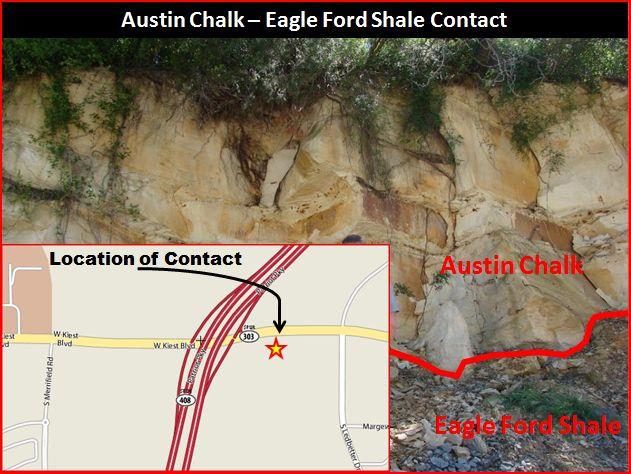
The Dallas–Fort Worth Metroplex is underlain by rock units spanning hundreds of millions of years. Moving west to east, you cross belts of progressively younger strata: Pennsylvanian (~323–299 Ma) sediments to the west, widespread Cretaceous (145–66 Ma) formations across much of the metroplex, and Paleocene (~66–56 Ma) deposits farther east.
These lithologic changes record repeated advances and retreats of ancient seas. The eastward dip of the strata primarily reflects long-term Gulf Coast basin subsidence and gentle post-depositional tilting.
That's why formations such as the Eagle Ford Shale and Austin Chalk crop out in roughly parallel belts, each marking different marine environments from shallow shelves to deeper waters. A large unconformity separates the Pennsylvanian and Cretaceous sections, representing ~150 million years of erosion and non-deposition.
Shaking Ground: Earthquake History in the Metroplex
Although North Texas was once considered seismically quiet, a notable shift began in 2008 with an earthquake sequence near DFW International Airport. Since then, instrumentation has detected several hundred events (many too small to feel), with felt magnitudes typically M~2–4 and the stronger recent DFW-area events approaching M3.8.
These tremors cluster along mapped faults and in areas of significant saltwater disposal, consistent with induced seismicity mechanisms. During one early sequence (late 2008–spring 2009), scores of small quakes were located by regional networks.
While serious damage and fatalities have not occurred in the metroplex, preparedness (securing shelves, reviewing insurance, and checking foundations) has become increasingly relevant.
Human Impact: How Wastewater Disposal Affects Fault Stability
With the rise of unconventional oil and gas activity, the Fort Worth Basin saw large-volume deep disposal of produced water, especially into the Ellenburger Group. Many faults remained stable until elevated pore pressures changed the effective stresses acting on fault planes. After 2008, the region recorded many more earthquakes than prior decades.
Regulatory adjustments and reduced injection volumes in certain areas after 2015 coincided with lower seismic rates in some sequences, consistent with a cause-and-effect link. Regionally, billions of barrels of fluids were injected over the 2006–2018 period, underscoring why pressure management and site selection matter for fault stability and public safety.
The Science Behind the Maps: Fault Detection and Research
Mapping North Texas faults relies on dense seismic monitoring and integrated geoscience. Texas' TexNet and university partners (including SMU) deploy broadband and short-period sensors, then apply template matching and cross-correlation to detect tiny events that standard catalogs miss. Nodal arrays and double-difference relocations tighten hypocentral accuracy and illuminate fault geometries.
Researchers link seismic catalogs with injection data, well logs, and 3-D subsurface models to estimate pressure diffusion and Coulomb stress changes. Numerical modeling helps quantify how far and how fast pressure perturbations can reach (often many kilometers), and what thresholds may trigger slip in specific fault segments.
Living on Faults: Understanding Urban Risk in North Texas
Living atop North Texas faults carries practical implications beyond the science. Even small fault slip can contribute to nuisance shaking, and repeated earthquakes may stress foundations and infrastructure—especially where expansive soils and drought-driven shrink–swell already challenge structures.
What's changed since 2008 is the frequency and clustering of local earthquakes. If you're near a known fault corridor, consider post-event foundation checks, keep heavy items secured, and review building and retrofit guidance appropriate for low-to-moderate seismicity regions. City planners and regulators increasingly incorporate geologic and injection-related data into risk-reduction strategies.
Conclusion
You're standing above a dynamic subsurface that's more active than it appears at the surface. North Texas lacks the major tectonic quakes of plate boundaries, but its intricate fault networks can respond to human-driven pressure changes. As monitoring and models improve, communities can balance growth with geologic realities—reducing risk while living atop a complex, evolving earth system.